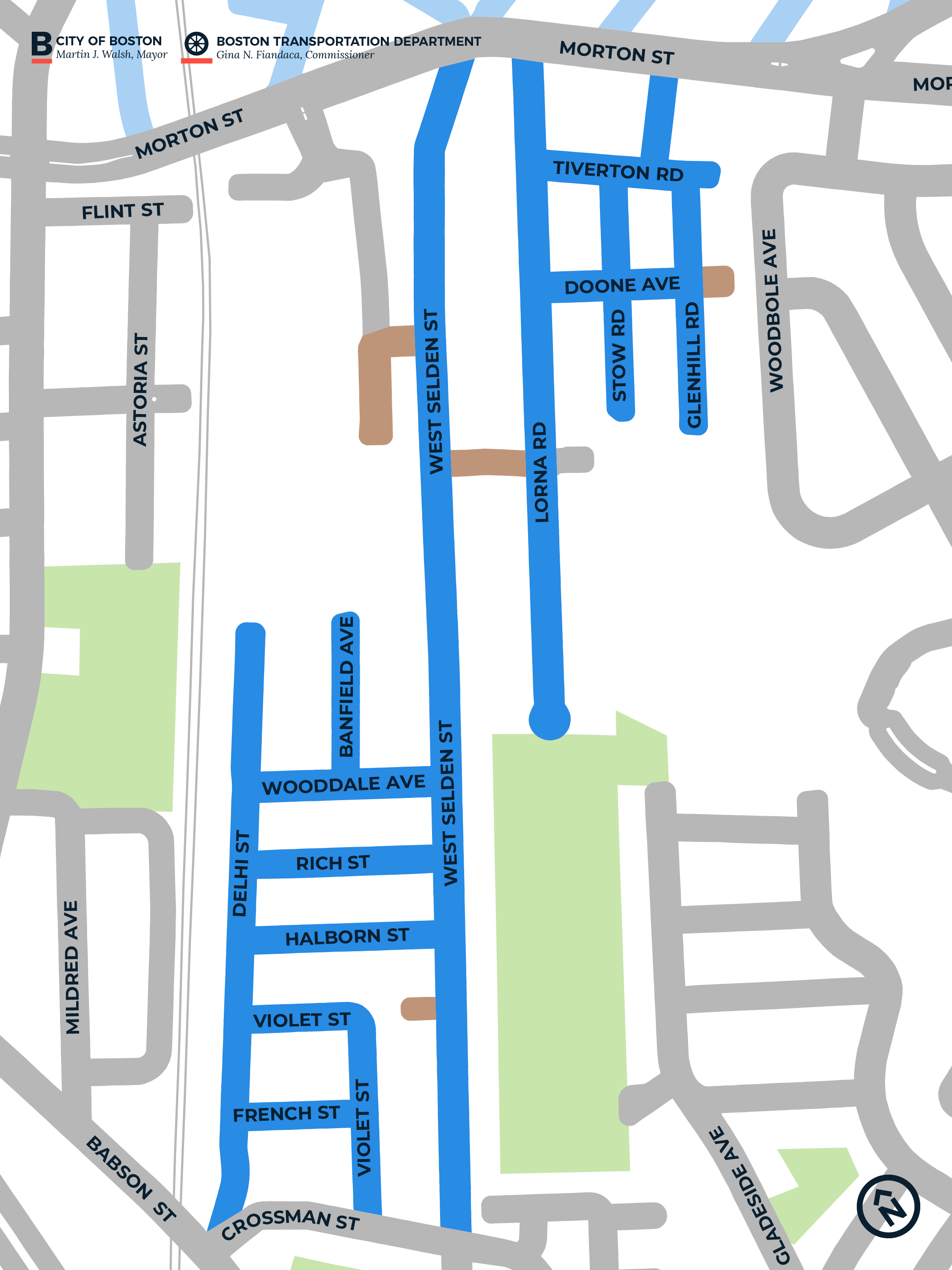
West Selden Street and Vicinity
This page contains information about the Neighborhood Slow Streets plan for the West Selden Street and Vicinity neighborhood.
Neighborhood Slow Streets is Boston's approach to traffic calming on residential streets. We're focused on street designs that self-enforce slower speeds and safer behaviors. Through this program, we aim to:
- reduce the number and severity of crashes on residential streets
- lessen the impacts of traffic, and
- add to the quality of life in our neighborhoods.
The West Selden Street and Vicinity neighborhood is one of five communities selected to join the program in 2018.
Construction update
Construction for your neighborhood is prioritized in 2022.
WHAT TO EXPECT WITH CONSTRUCTION:
When construction is scheduled, we will send an update to our email list for that zone. Construction crews will post "No Parking" signs at least 48 hours before any work that impacts parking.
Our Neighborhood Slow Streets program makes lasting safety improvements for our residents. Each zone's design includes reconstruction of several intersections. That's in addition to tools such as speed humps, pavement markings, and signs. Our engineered design plans have been fully approved and are ready for construction.
You can expect different construction crews for each part of the design plan. Construction schedules are weather-dependent. You can generally expect the following:
-
Speed humps: Construction may take a few days. The speed humps will have temporary paint and signage.
- Clear corners: Signs and pavement markings for clear corners have already been installed.
View the plan!
View the West Selden Streets and Vicinity Neighborhood Slow Streets plan:
New Crosswalks on West Selden Street
Henrici Street and West Selden Street
woodale avenue and west selden street
Project History
HistoryTake a look at the updates shared at a neighborhood meeting on November 25.
We shared draft concept designs at a public meeting on June 10. We invite residents to continue to provide feedback as we advance the designs.
We joined community members for a neighborhood walk on Monday, October 15, 2018, at 5 p.m. This walk was an opportunity for community members to share their transportation-related safety concerns. We started at Morton Street and Owen Street and neighbors were welcome to join all or some of the walk.
The walk was not the only time or place for community members to provide input on the Neighborhood Slow Streets project. Neighbors can also share their concerns:
- on the Vision Zero Safety Concerns map
- by sending an email to visionzero@boston.gov
- by calling 617-635-4765, or
- at future community meetings.
What we learned from the walk will supplement:
- engineering observations
- data collected through speed and volume studies, and
- the information provided on the Safety Concerns map and through email and phone calls.
We shared draft concept designs at a public meeting on June 10. Please review the presentation and provide your feedback.
Zone map
Zone streets* - Streets that will be evaluated for traffic calming improvements
Private ways - Streets that are privately owned, so we will not be able to make changes to them
Streets in other zones - Streets that are being evaluated for traffic calming as part of other zones
Other streets - Streets that are outside of the zone, regardless of who owns them, or streets that are within the zone boundaries and will not be evaluated for traffic calming
Open space - Parks and other open spaces
*All streets that we will consider for changes are marked as "zone streets." During the planning process, we may determine that some streets won’t see any changes. We generally will not consider any additional streets that are not marked as "zone streets."
2018 Application Period
Neighborhood Slow Streets prioritizes street safety improvements in areas:
- with a history of serious crashes
- with a high number of residents more likely to be killed or seriously injured walking or biking (children, older adults, and people living with disabilities)
- that include places people may walk or bike to (schools, libraries, parks, community centers, bus stops, or transit stations), and
- are near existing or planned opportunities for walking, biking, or taking transit.


