Dorchester Unified Neighborhood - East and West
This page contains information about the Neighborhood Slow Streets plan for the Dorchester Unified Neighborhood East and West Slow Streets Zones.
Neighborhood Slow Streets is Boston's approach to traffic calming on residential streets. We're focused on street designs that self-enforce slower speeds and safer behaviors. Through this program, we aim to:
- reduce the number and severity of crashes on residential streets
- lessen the impacts of traffic, and
- add to the quality of life in our neighborhoods.
The Dorchester Unified Neighborhood (West Codman Hill) consists of two Slow Streets Zones:
- Dorchester Unified Neighborhood East, and
- Dorchester Unified Neighborhood West.
Three other communities were selected to join the program in 2018.
Construction update
Construction for your neighborhood is prioritized in 2022.
WHAT TO EXPECT WITH CONSTRUCTION:
When construction is scheduled, we will send an update to our email list for that zone. Construction crews will post "No Parking" signs at least 48 hours before any work that impacts parking.
Our Neighborhood Slow Streets program makes lasting safety improvements for our residents. Each zone's design includes reconstruction of several intersections. That's in addition to tools such as speed humps, pavement markings, and signs. Our engineered design plans have been fully approved and are ready for construction.
You can expect different construction crews for each part of the design plan. Construction schedules are weather-dependent. You can generally expect the following:
-
Speed humps: Construction may take a few days. The speed humps will have temporary paint and signage.
-
Curb extensions at Fairmount Street and Ogden Street, and Milton Avenue and Edson Street: Construction may take a week or more. The intersection will be repaved. Final pavement markings will be installed no sooner than 72 hours after repaving.
-
Clear corners: Signs and pavement markings for clear corners have already been installed.
Learn about street safety design tools
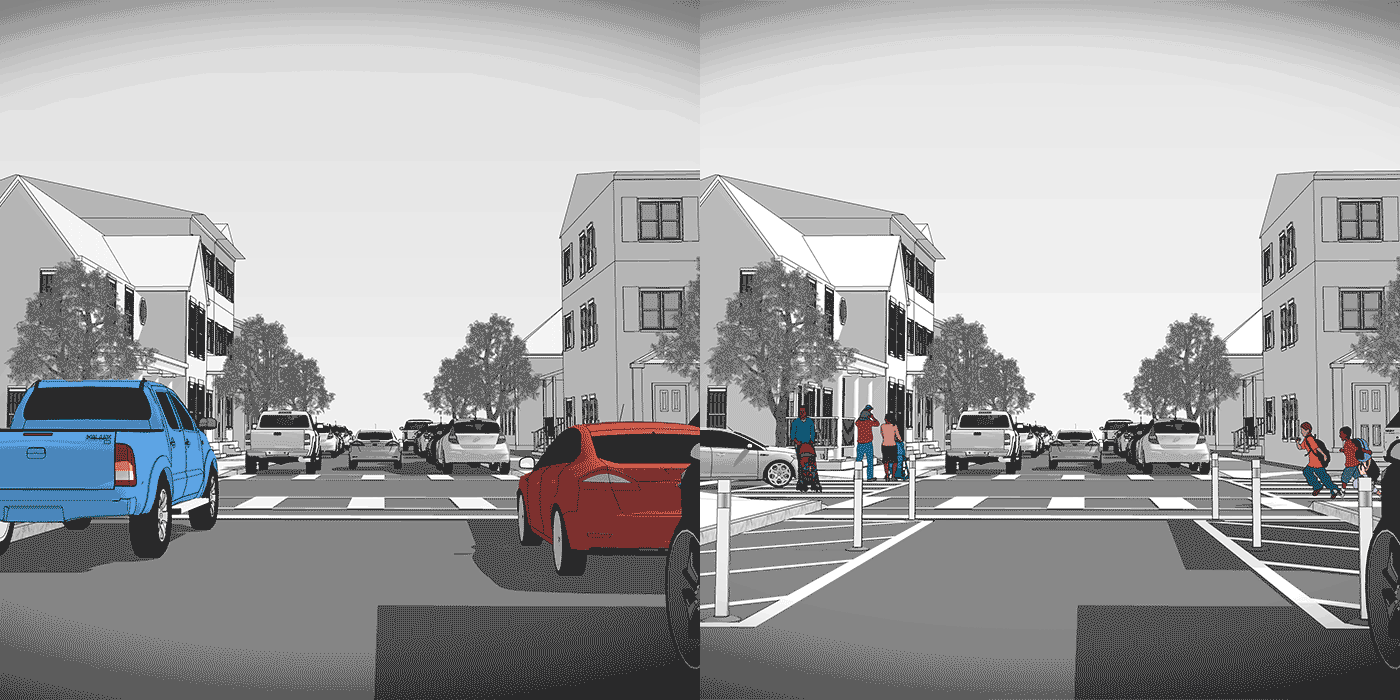
cLEAR CORNERS/PARKING RESTRICTIONS
Parking is prohibited ahead of a crosswalk or intersection. Parked vehicles or other obstructions can block views of other people driving, biking, or waiting to cross. When parking is restricted, drivers are more likely to see approaching vehicles or people crossing the street. This reduces the likelihood of crashes at intersections.
Clear corners also make it easier for fire trucks, delivery trucks, and other larger vehicles to turn. With clear corners, these bigger vehicles are less likely to scrape other parked cars or get stuck.
We add "No Parking" signs to mark the area where parking is prohibited. We can also add a painted box with diagonal lines and plastic posts in the space as a reminder. In construction projects, we can build curb extensions using granite and concrete to prevent people from parking too close.
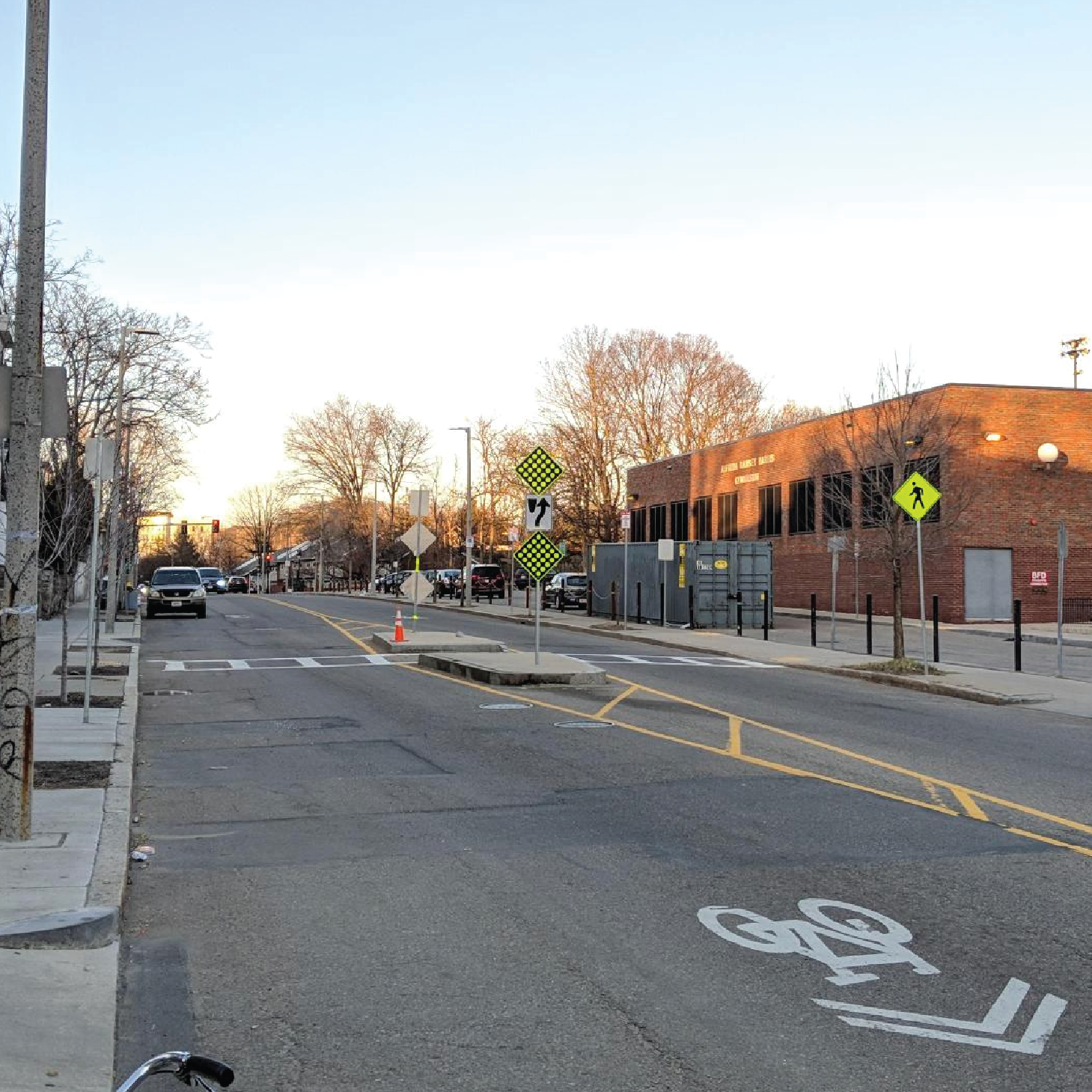
CROSSING MEDIANS
A crossing island allows people to pause while crossing multiple travel lanes. Crossing islands help people feel safer at intersections or mid-block crossings. They enable people to cross the street in two stages. Crossing islands can also slow turning traffic by ensuring that drivers cannot “cut” turns quickly.
We can create crossing islands with pavement markings and vertical flexible posts. We can also build them with raised areas of concrete and granite.
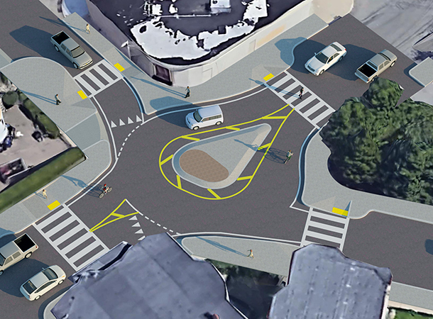
mini-roundabouts
Roundabouts feature a center island, crossing islands, and curb extensions. The crossing islands and curb extensions slow and direct drivers as they enter the roundabout. Drivers must pause and watch for people crossing on foot first. Then, they look for oncoming vehicles. This makes it safer for people on foot and simplifies things for drivers.
Roundabouts are a type of circular intersection. However, they are different from rotaries and traffic circles often seen in Boston and other New England cities. Roundabouts feature much smaller circles and are designed to promote slow entry and circulating driving speeds. Drivers do not need to change lanes as they move along the roundabout. Rotaries have much higher entry and circulating speeds. Changing lanes is often needed to complete certain movements.
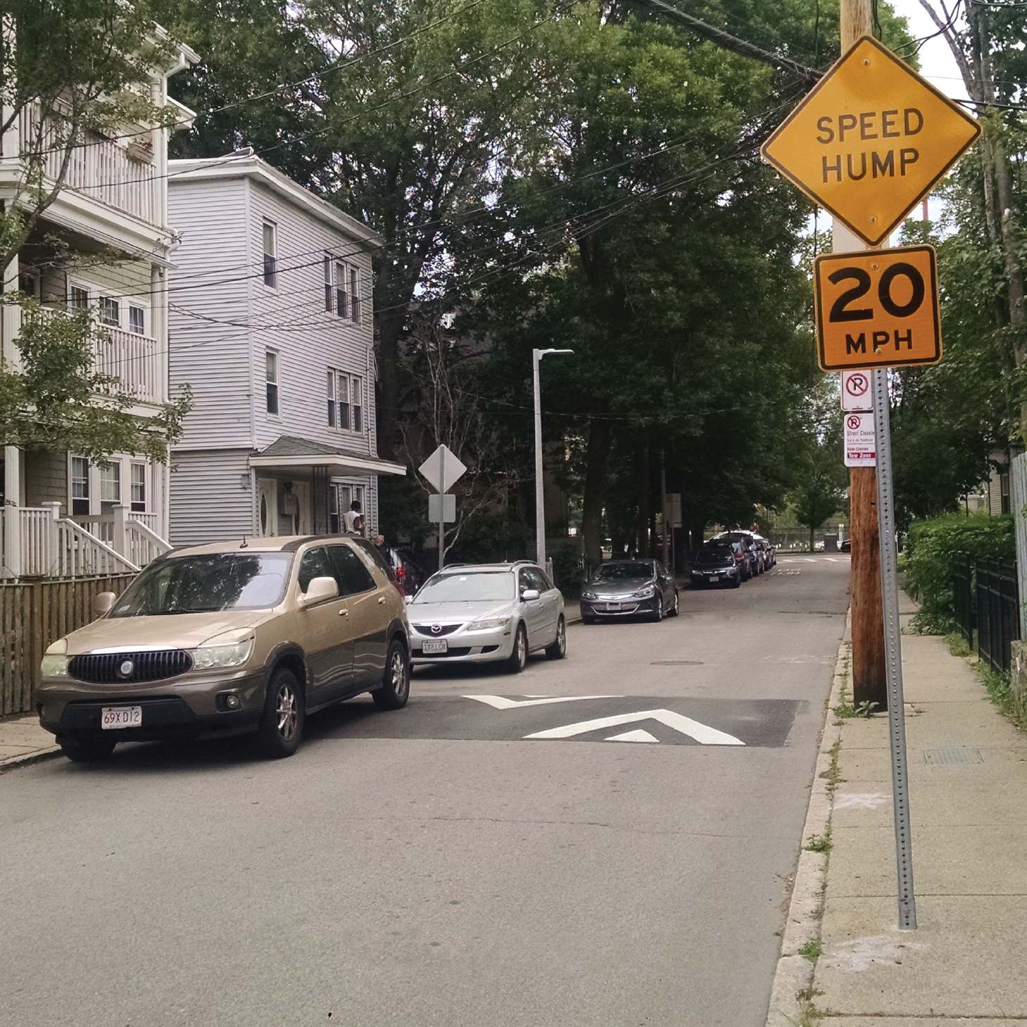
speed humps
Speed humps are a series of gradual mounds of asphalt in the street. They are three inches high and 12- to 14-feet long. Speed humps are comfortable to drive over at 20 miles per hour or less. We paint white triangles on the street and install yellow “Speed Hump” signs so drivers are aware.
We only use speed humps on streets that are relatively flat, straight, and are one or two lanes wide. Speed humps are built every 150 to 250 feet apart to prevent drivers from speeding between them. Speed humps do not impact drainage, street sweeping, snow removal, or street parking.
Speed humps are only used on smaller “side” streets. They are not appropriate for wider, busier streets or for streets with MBTA bus routes.
View the plan!
View the safety improvements we'll install as part of the Dorchester Unified Neighborhood and Redefine Our Community Neighborhood Slow Streets zones.
A closer look
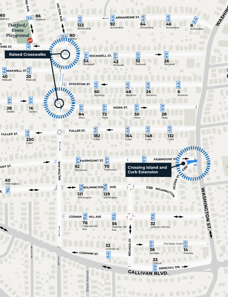
east of Milton Avenue
On side streets west of Milton Avenue, east of Washington Street, north of Gallivan Boulevard, and south of Roberts Playground, we'll install:
- a series of speed humps to slow speeds to 20 to 25 mph
- raised crosswalks to provide a safe crossing at Milton Avenue and Mora Street and Milton Avenue and Rockwell Street
- a safer crossing at Fairmount Street, Ogden Street, and Washington Street, and
- corner parking restrictions to discourage parking too close to crosswalks and improve your ability to see cross-traffic at intersections.
Click on image twice to view larger
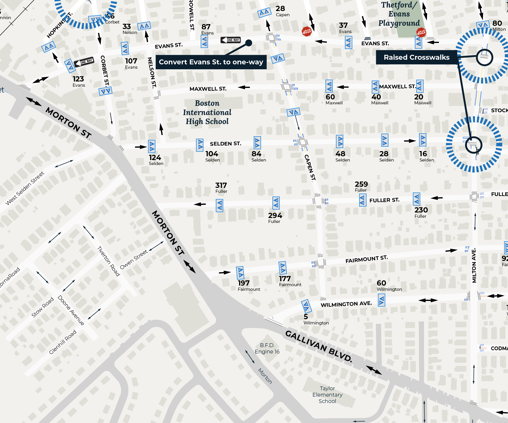
Click on image twice to view larger
west of Milton Avenue
On the streets east of Milton Avenue, north of Gallivan Boulevard, and east of Morton Street, we'll install:
- speed humps to slow speeds to 20 to 25 mph
- corner parking restrictions to discourage parking too close to crosswalks and improve your ability to see cross-traffic at intersections, and
- convert Evans Street to a one-way street, as residents requested.
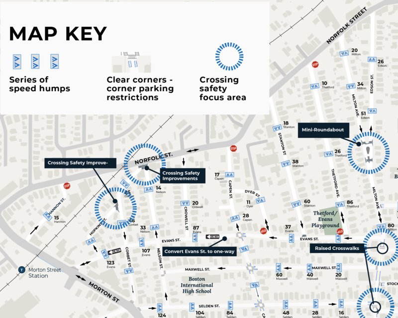
North of evans street
The streets north of Evans Street, east of Morton Street, south of Norfolk Street, and west of Edson Street are part of the Redefine Our Community Neighborhood Slow Streets zone. We'll install:
- speed humps to slow speeds to 20 to 25 mph
- a mini-roundabout and crosswalk improvements at the intersection of Milton Avenue and Edson Street
- crossing improvements at Norfolk Street, Nelson Street, and Corbet Street
- crossing improvements at Hopkins Street and Corbet Street, and
- convert Evans Street to a one-way street heading toward Morton Street, as residents requested.
Key Safety Improvements
Milton Avenue (Between Mora Street and Rockwell Street)
We're adding raised crosswalks and improving visibility on Milton Avenue
Milton Avenue and Edson Street
We're creating a safer crossing and slowing speeds on where Milton Avenue and Edson Street meet
Ogden Street and Fairmount Street
We're creating a safer crossing and slowing turns where Ogden Street and Fairmount Street meet.
Project History
HistoryWe talked about the design and what to expect for construction at the D.U.N. Neighborhood Association meeting.
This summer, we reviewed your feedback and updated traffic-calming concepts for this Neighborhood Slow Streets zone.
We shared concept designs at the Dorchester Unified Neighborhood Association public meeting on May 29 at the Boston International High School.
At the Redefine Our Community Slow Streets meeting on June 20, 2019, we shared traffic-calming concepts for streets north of Evans Street, including the Milton Avenue/Edson Street intersection.
We joined community members for a neighborhood walk on Saturday, October 20, 2018, at 1 p.m. This walk was an opportunity for community members to share their transportation-related safety concerns. We started at Milton Avenue and Armandine Street. Neighbors were welcome to join all or some of the walk.
The walk was not the only time or place for community members to provide input on the Neighborhood Slow Streets project. Neighbors can also share their concerns:
- on the Vision Zero Safety Concerns map
- by sending an email to visionzero@boston.gov
- by calling 617-635-4765, or
- at future community meetings.
What we learned from the walk will supplement:
- engineering observations
- data collected through speed and volume studies, and
- the information provided on the Safety Concerns map and through email and phone calls.
Street Safety Design Tools
Learn about the tools in this Neighborhood Slow Streets plan and how we use them to make streets safer.
2018 application period
Neighborhood Slow Streets prioritizes street safety improvements in areas:
- with a history of serious crashes
- with a high number of residents more likely to be killed or seriously injured walking or biking (children, older adults, and people living with disabilities)
- that include places people may walk or bike to (schools, libraries, parks, community centers, bus stops, or transit stations), and
- near existing or planned opportunities for walking, biking, or taking transit.


